World Atlas Physical Geography Spread
This is a Documents & Publishing AI image prompt case, leaning toward Editorial, Vintage, Realistic. Copy the full prompt below and paste it into a free GPT image generator to create your own image with GPT Image-2 — swap the subject, brand, or aspect ratio as needed.
English full prompt
A two-page atlas spread showing a physical relief map of Southeast Asia and the Indonesian Archipelago, opened flat on a light wooden table, photographed from directly above. The map uses a traditional shaded relief style — mountain ranges rendered in brown-grey terrain shading with fine contour lines, lowlands in muted sage green, shallow seas in pale turquoise fading to deep blue at ocean trenches. Printed on slightly glossy large-format paper with a fine grid of latitude and longitude lines every 5 degrees. Place names in various weights: country names in 14pt bold spaced capitals; major cities in 9pt roman with a small circle glyph; island names in 8pt italic. The map projection label at lower-left reads "Lambert Conformal Conic Projection — Scale 1:12,000,000". A scale bar, north arrow, and legend box sit in the lower-right corner. The legend labels depth bands: "0–200m", "200–1000m", "1000–4000m", ">4000m" in a gradient from pale blue to deep indigo. Page numbers "118 | 119" at foot, with the spread title "SOUTHEAST ASIA — PHYSICAL" in 10pt small-caps at the top center gutter.
中文完整提示词
一张东南亚及印尼群岛自然地形地图集双页展开,平铺于浅木桌,正上方俯拍。地图采用传统晕渲地形风格——山脉以褐灰地形晕渲配细等高线表现,低地哑光鼠尾草绿,浅海淡青渐变至大洋深蓝。印于略光泽大幅纸张,每5度经纬网格线。各级地名字重:国名14pt粗体间距大写,主要城市9pt正体配小圆圈符号,岛名8pt斜体。左下角投影标注「世界地图册自然地理跨页」。比例尺、北方向箭头与图例框置于右下角。图例标注深度分级:「0–200m」、「200–1000m」、「1000–4000m」、「0–200m」,浅蓝到深靛蓝渐变。页脚页码"118 | 119",顶部中缝10pt小型大写标题「SOUTHEAST ASIA — PHYSICAL」。
Related cases

Gothic Fiction Hardcover Book Cover
A flat-lay photograph of a finished hardcover book lying on aged oak, shot overhead with a 50mm tilt-shift lens in dim candlelight. The cover is deep burgundy cloth with gold foil…

Sci-Fi Novel Full Dust-Jacket Spread
A full unfolded dust-jacket spread laid flat on a light-box, photographed straight-on — showing front cover, spine, and back cover as one continuous panoramic image. The front cov…

Kids Picture Book Interior Spread
A two-page picture-book interior spread for ages 4-7, painted in opaque gouache with clean flat color and hand-painted texture. Left page: a small bear in a yellow raincoat stands…
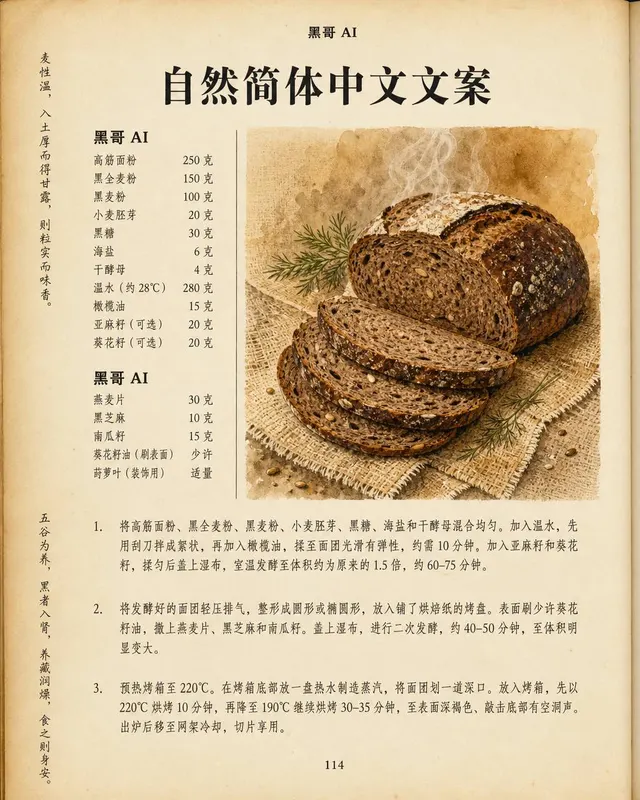
Artisan Recipe Book Page Layout
A high-fidelity scan simulation of a single right-hand page from a premium recipe book, printed on slightly textured cream stock. Page header in small-caps: "CHAPTER FOUR — SLOW B…