卫星图像注释叠加地图
这是一个「地图与制图」类别的 AI 生图提示词案例,风格偏向写实、编辑设计、纪实。复制下方完整提示词,打开免费 GPT 生图工具粘贴,即可用 GPT Image-2 免费出图,并可替换主体、品牌名与画幅。
中文完整提示词
虚构海滨城市「Narvel Bay」的卫星图像叠加分析地图,作为情报或环境分析叠加层呈现。底图为超写实俯视卫星视角:棕褐城市街区、深蓝水域、绿色公园、蜿蜒河口三角洲、集装箱码头与机场跑道网格。半透明注释层叠加:黄色多边形标注「Old Town」「Industrial Fringe」「Esplanade Quarter」等主要区域,白色细线指向具体特征,红色圆圈标注兴趣点,蓝色虚线追踪海岸侵蚀边界。刻度尺与坐标格栅以哑光青绿叠加,注释字体为清晰等宽技术字体,呈现军用地图或GIS导出产品的精准分析气质。
English full prompt
A composite satellite-imagery-style map of the fictional coastal city "Narvel Bay", presented as an annotated intelligence or environmental analysis overlay. The basemap is a hyper-realistic top-down satellite view showing tan urban blocks, dark blue water, green park patches, a sinuous river delta, port infrastructure with container terminals, and an airport runway grid. Over this photorealistic base, a semi-transparent annotation layer adds: yellow polygons labelling major districts ("Old Town", "Industrial Fringe", "Esplanade Quarter"), white hairline call-out lines pointing to specific features, red circle markers for points of interest, and a dashed blue line tracing the coastline erosion boundary. A scalebar and coordinate grid overlay are visible in a muted teal. The annotation typography is a crisp technical monospace font, like a military cartographic product or a GIS export. The mood is precise, analytical, and slightly dramatic.相关案例
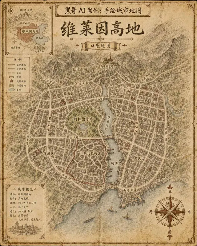
手绘虚构城市地图
一张虚构城市「Verlaine Heights」的手绘街道地图,以棕色墨水绘于泛黄奶油色绘图纸上,俯视正交视角。密集的街道网格、一条将城市一分为二的河流、中央公园标注为「Allard Green」,以及蜿蜒的历史街区。街道名以略显不规则的衬线手写体标注,右下角绘有装饰性罗盘玫瑰,左上角有显示周边区域的小插图。铅笔排线…
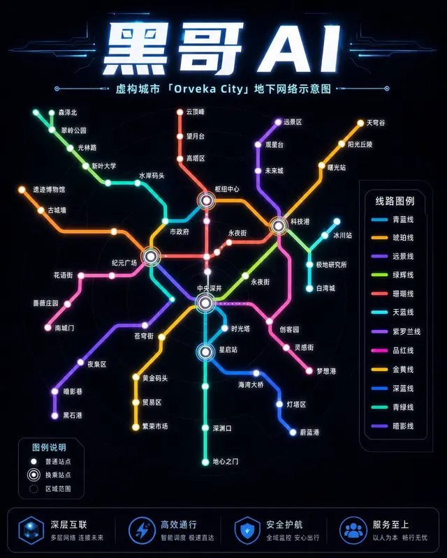
霓虹深色地铁线路图
虚构城市「Orveka City」地下网络的简洁线路示意图,背景为近黑色(#0d0d14)。十二条彩色线路以45度角弧线交织,包括荧光绿、霓虹珊瑚红、天蓝、琥珀、紫罗兰等。站点为白色圆点,换乘站为多环标记。站名以紧凑无衬线字体显示,带轻微辉光效果。图例列出「Cerulean Line」「Amber Line」「Van…
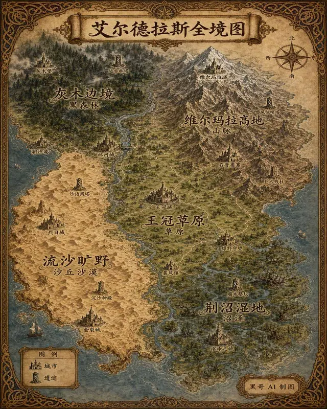
插画风奇幻世界全览地图
生成一张 4:5 竖版「插画风奇幻世界全览地图」案例图,所属分类为「地图与制图」。奇幻大陆地图,羊皮纸背景,各区域彩绘、城堡图标与花体地名。画面需要完整呈现上述主体、构图、配色、材质、光线和整体风格;可见文字以自然简体中文为主,必要的技术缩写、代码、变量名、学术符号、单位、拉丁物种名或装饰性外文可保留。
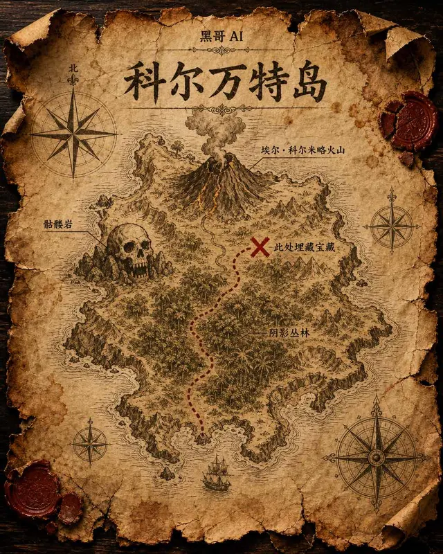
藏宝岛羊皮纸地图
虚构岛屿「Isla de Corvante」的磨损羊皮纸藏宝图,以泛黄墨水绘于皱折牛皮纸上。海岸线用细致排线描绘,内陆有火山「El Colmillo」、丛林「Selva Sombría」、骷髅岩「Peñasco Calavera」,以及标注「Aquí yace el tesoro」的X宝藏位置。虚线小径从南岸海湾穿越…